Day Ten
Capital Reef, Glen Canyon, Natural Bridges, Canyonlands
Leaving Tropic we headed to our next destination of Capital Reef National Park. But first we would have to drive through the largest and newest National Monument in the lower 48-The Grand Staircase-Escalante National Monument. This is an immense monument that is not run by the NPS. This is also the newest NM and we had hoped to get a taste for this park, but the available information was sparse at best. There was an information center in Escalante, but it was not open on the day we past. It contains an incredible landscape of rock and wide open spaces. There are few pull outs to enjoy the scenery, but the drive alone was spectacular. The raod itself is a draw for those that love driving on technically challanging roads. At one point, we were driving on a ridge that was less than 100' wide. On both sides of us we could see a plumeting cliff that dropped over 2,000'!
The day was going to include many of these surprises which when you add them up, made this day one of the best of the trip. Our next stop was Captial Reef National Park. Our plan was to stop at the visitor center and then travel east to the Notom-Bullfrog Road and then south along the eastern flank of the park. A giant, sinuous wrinkle in the Earth's crust stretches for 100 miles across south-central Utah. This impressive buckling of rock, created 65 million years ago by the same tremendous forces that later uplifted the Colorado Plateau, is called the Waterpocket Fold. Capital Reef National Park preserves the fold and its spectacular, eroded jumble of colorful cliffs, massive domes, soaring spires, stark monoliths, twisting canyons, and graceful arches. The Notom-Bullfrog Road is an unpaved strech of road that travels east of the Waterpocket Fold. This is one of the last regions of the west to be fully explored. In fact, the Henry Mountains which fram the valley to the east of the raod were the last named mountain range in the continental U.S. Today we are told, that the raod is clear, but a high clearance 4wd vehicle is required to traverse it. If you choose any of the unpaved road around the park (including the infamous Burr Trail), you want to check in with the rangers at the park vistor center because they have rangers check each of these roads daily and report their status. Our raod is very wash board like which makes it a rough ride. We have to deal with this for almost 200 miles. The road itself was fine, but form time to time we had to cross 'washes' that had been flooded over a few days previous. Some of these were minor requiring a slow down but a one required us to get out of the car and examine the conditions. After some careful thought, we decided to carry on and go for it. We had to drive down the river bed for a bit and then traverse the bank to get back to the road. We had no problems, though the tires did spin a bit but we were always moving forward. We carried on southward once back on the road. We stopped halfway to take some pictures of the fold and we enjoyed absolute solitude. Only once did a car pass us while we were their and there was almost pur scilence too. We reached the end of the unpaved road which almost feels like civilization, and continue south toward the Bullfrog Marina located on Lake Powell.
Once on a paved road, we thought all our problems were over. One tip for those that may travel in this area is to have a good map with you. We were using both Delome paper topo maps as well as the software version using a gps unit. Having found the right road we were travelling at a pretty good clip and came to the top of a hill when we could see what laid on the bottom of the hill...a washed out road. The raod was completely washed out and covered by several feet of mud. There was no sign and no warning had been given to us at the visitor center. Perhaps it was too far to the south for them to know. The bad thing was that we were only about 10 miles from the Bullfrog Marina, where we needed to go to cross the lake. So, we put the car in 4wd low and went for it. The mud went every where and covered the car, but we made it! We arrived at the ferry at the moment it was about to take off, but the deck hands allowed us to broad, probably looking the condition of our vehicle and feeling that we deserved it.
We were crossing Lake Powell, part of the Glen canyon National Recreation Area. Throughout hsitory, humans have adapted their surroundings to better suit their needs. Glen Canyon NRA, established in 1972, provides a dramatic example of one of natures most inspiring setting combind with an ambitious human project. Impounded behind the Bureau of Reclaimation's Glen Canyon Dam, waters of the Colorado River and tributaries are backed up about 185 miles, forming Lake Powell. The lake and more than one million acres of desert-and-canyon country offer leisure-time activities for American and international visitors. Our crossing would take about 30 minutes and would offer us a forced break from driving and exploring. Along the lake shore also lies another NPS site, Rainbow Bridge National Monument. Rainbow Bridge, the worlds largest natural bridge, is considered a sacred place by the Navajo Indians, for whom personified rainbows have stood as guardians of the universe. Until the formationof Lake Powell, this was one of the most remote and inaccessible regions in the contiguous United States.
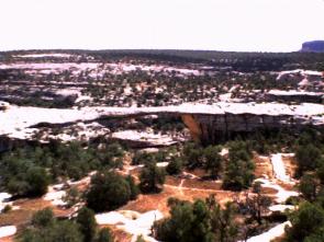 Having crossed the lake, we made our way to our next stop, Natural Bridges National Monument. Where Rainbow Bridge represents the largest natural bridge in the world, Natural Bridges contains no.'s 2,3, and 4. The bridges here represent the three stages like old age, maturity, and youth. The vistor center can provide you information and direct you where to go along the 9 mile one way loop road. There are three distinct bridges to see, but time being of the essence, we only had time to really see one. We choose the most graceful, Owachomo. The others are higher and maybe longer, but we felt that we really needed to see just one to get an idea of this monument. A complete visit would only require about an hour or so, so it is worth a visit, don't get us wrong. It was just our schedule that didn't allow us more. Having crossed the lake, we made our way to our next stop, Natural Bridges National Monument. Where Rainbow Bridge represents the largest natural bridge in the world, Natural Bridges contains no.'s 2,3, and 4. The bridges here represent the three stages like old age, maturity, and youth. The vistor center can provide you information and direct you where to go along the 9 mile one way loop road. There are three distinct bridges to see, but time being of the essence, we only had time to really see one. We choose the most graceful, Owachomo. The others are higher and maybe longer, but we felt that we really needed to see just one to get an idea of this monument. A complete visit would only require about an hour or so, so it is worth a visit, don't get us wrong. It was just our schedule that didn't allow us more.
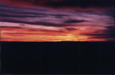
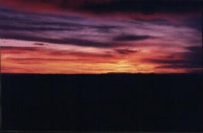 We were trying to get to our final desitination of the day, Canyonlands National Park. We wanted to get there for sunset, and have a choice of where to go. Canyonlands preserves an immense wilderness of rock at the heart of the Colorado Plateau. Water and gravity have been the prime architects of this land, cutting flat layers of sedimentary rock into hundreds of colorful canyons, mesas, buttes, fins, arches and spires. At center stage are two great canyons, those carved by the Green and Colorado Rivers. Surrounding the rivers are vast, and very different, regions of the park:to the north, Island in the Sky; to the west, the Maze; and to the east, the needles. Few people dared to enter this region before the park was established in 1964. To a large degree, Canyonlands remains untrampled even today. Even outside of the park, the scenery is awesome. Take for example our drive to the Needles. We travelled through an incredible area that can only be described as awsome. We were surrounded by these massive mesas of stone that looked like cathedrals, or temples. These mesas had the effect to make us feel small, which put us in our place. If you travel to one place in Canyonlands, this drive alone makes it worth it. Its hard to pick one place to visit in Utah, but for me, this would be on the short list. Too bad its not in the park though. We made our way around to go to the Island in the Sky, which was only about 20 lateral miles from the Needles, a 120 mile drive. There we saw what was perhaps the most spectacular sunsets of the trip. Canyonlands is a unique park in that is lies next to Arches National Park, and the popular town of Moab, yet it is mostly unexplored. The majority of the park is a remote backcountry alowing the visitor to fully see this wonderful desert country. Most of the roads in the park are for 4wd vehicles. Cars can see it, but they just can't explore it. That's best left for your feet or a 4wd. We were trying to get to our final desitination of the day, Canyonlands National Park. We wanted to get there for sunset, and have a choice of where to go. Canyonlands preserves an immense wilderness of rock at the heart of the Colorado Plateau. Water and gravity have been the prime architects of this land, cutting flat layers of sedimentary rock into hundreds of colorful canyons, mesas, buttes, fins, arches and spires. At center stage are two great canyons, those carved by the Green and Colorado Rivers. Surrounding the rivers are vast, and very different, regions of the park:to the north, Island in the Sky; to the west, the Maze; and to the east, the needles. Few people dared to enter this region before the park was established in 1964. To a large degree, Canyonlands remains untrampled even today. Even outside of the park, the scenery is awesome. Take for example our drive to the Needles. We travelled through an incredible area that can only be described as awsome. We were surrounded by these massive mesas of stone that looked like cathedrals, or temples. These mesas had the effect to make us feel small, which put us in our place. If you travel to one place in Canyonlands, this drive alone makes it worth it. Its hard to pick one place to visit in Utah, but for me, this would be on the short list. Too bad its not in the park though. We made our way around to go to the Island in the Sky, which was only about 20 lateral miles from the Needles, a 120 mile drive. There we saw what was perhaps the most spectacular sunsets of the trip. Canyonlands is a unique park in that is lies next to Arches National Park, and the popular town of Moab, yet it is mostly unexplored. The majority of the park is a remote backcountry alowing the visitor to fully see this wonderful desert country. Most of the roads in the park are for 4wd vehicles. Cars can see it, but they just can't explore it. That's best left for your feet or a 4wd.
|