Day Nine
Zion, Cedar Breaks, Bryce Canyon
A cool start to a lovely day and we head out for our first National Park of the day, Zion. Zion National Park is a spectacular cliff and canyon landscape. Its like Yosemite in color. After a stop at the visitor center, we made our way up through Zion Canyon. This canyon was carved by the Virgin River millions of years ago. Stoping at a few places admiring the scenery that lay before us and photographing this difficult landscape as best we could, the canyon narrowed to a point called the narrows. A very easy path parallels the river here and takes you over a mile from the main road to a point where the trail then enters the Virgin River to the Narrows. Many people at this point were wading through the river to this area. The colors of the trees this time of year here made for spectular scenery. The plethera of colors and landscapes around us was almost overwhelming. The vally was just one part of this spectacular area. We left the valley and headed east to go to our next stop today. What we saw over the next 200 miles was totally unexpected. First, the eastern entrance to Zion was completly underated from what I had read. I thought it was one of the most incredible landscapes I had seen. It felt like driving through a alien landscape of rock and sparse green vegetation which added to the sensation. If you visit Zion, be sure to check this area out.
Our original goal was to head out to Bryce Canyon National Park, but looking at the map, we realized that Cedar Breaks National Monument was just a little off our planned drive, and it was good thing that we noticed it. The road west climbed to over 10,000 feet taking us into another world. Atop the Markagunt Plateau is the highcountry of Cedar Breaks. It is a world every bit as rich in color and as delicate in form as the rock amphitheater below, yet it is a very different place. Here you can immerse yourself in the lushness of the scenery, breathe in the intoxicating fragrance of spruce-fir forests, and tread softly through subalpine meadows of grasses and seasonal wildflowers. In this sactuary of clean, cool air, abundant rainfall, full sunlight, and fertile soil, nature exhibits its full irrepressible potential. Cedar Breaks is much like the landscape at Bryce Canyon, yet what is confounding is the elevation at which this landscape occurs-over 10,000 feet. We even found snow here on this crisp cool autumn day. Whether travelling between Zion and Bryce Canyon or driving south on I-15, Cedar Breaks is a worthy stop. Lucky too that we came this way as we stopped to photograph the foliage around an alpine lake.
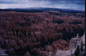 The weather is turning on us as we head towards Bryce, but no so much that it disipates the surrounding landscapes. We are planning to be at Bryce Canyon for sunset, so that would be a set back if it did begin to rain. And, as it turns out it did. After visiting the visitor center of Bryce Canyon National Park, it began to rain. From what we can see with the vast views from atop the plateau we are on, it looks like a localized shower that will disapate. Had we had our mobile net connection, we would have been able to track this thing using radar, but we can't. We drive all the way to the end of the park (Rainbow Point) where it looks sunnier. The elevation here is over 9,000 feet and it is said that the visibility here is only limited by the curvature of the earth. The rain is to our north but it is now moving in our direction. So, we head north to the main part of what is called Bryce Canyon. Bryce Canyon is a vast canyon amphitheater comprised of thousands of Hoo Doos. A Hoo Doo is a pilar of rock usually of fantastic shape, and here in southern Utah is made up of red shaded rock. Its is a landscape that dramically contrasts with the blue of the sky and the green of the trees. We park ouselves at Sunset Point and capture photos of the canyon and the sunset before us. The weather is turning on us as we head towards Bryce, but no so much that it disipates the surrounding landscapes. We are planning to be at Bryce Canyon for sunset, so that would be a set back if it did begin to rain. And, as it turns out it did. After visiting the visitor center of Bryce Canyon National Park, it began to rain. From what we can see with the vast views from atop the plateau we are on, it looks like a localized shower that will disapate. Had we had our mobile net connection, we would have been able to track this thing using radar, but we can't. We drive all the way to the end of the park (Rainbow Point) where it looks sunnier. The elevation here is over 9,000 feet and it is said that the visibility here is only limited by the curvature of the earth. The rain is to our north but it is now moving in our direction. So, we head north to the main part of what is called Bryce Canyon. Bryce Canyon is a vast canyon amphitheater comprised of thousands of Hoo Doos. A Hoo Doo is a pilar of rock usually of fantastic shape, and here in southern Utah is made up of red shaded rock. Its is a landscape that dramically contrasts with the blue of the sky and the green of the trees. We park ouselves at Sunset Point and capture photos of the canyon and the sunset before us.
Before total darkness, we make way for the town of Tropic, to find our lodgings for the night.
|