Day Twenty
Yellowstone, Bear Tooth, Little Bighorn, Devils Tower
We arose early this morning to get a head start on the distance we have to cover. Our plan was to hit breakfast and then drive through Yellowstone and onward. We don't really need to spend too much time there as we both have been there many times and its already covered ground. We just need to go through there to get up to Montana.
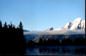 To our surprise though, the clouds that obscured the sky the night before and fresh air mass that enveloped the area, laid a layer of clouds over Jenny Lake at the foot of the Tetons. That fog bank had now lifted in the early morning light to about halfway up the Tetons. Never one to miss a photo opportunity, we imeadiatly headed down to the lake shore in an attempt to capture this moment. Its a very cold morning for this time of year (about 15 deg.), which has left a soft misting film across the still waters of Jenny Lake. Its an incredible sight with the mountains reflecting on the water and the cloud deck sitting in front of us. It allows us to see the mountains and the cobalt blue sky above and the whole scene below too. To our surprise though, the clouds that obscured the sky the night before and fresh air mass that enveloped the area, laid a layer of clouds over Jenny Lake at the foot of the Tetons. That fog bank had now lifted in the early morning light to about halfway up the Tetons. Never one to miss a photo opportunity, we imeadiatly headed down to the lake shore in an attempt to capture this moment. Its a very cold morning for this time of year (about 15 deg.), which has left a soft misting film across the still waters of Jenny Lake. Its an incredible sight with the mountains reflecting on the water and the cloud deck sitting in front of us. It allows us to see the mountains and the cobalt blue sky above and the whole scene below too.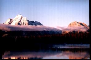 It will be a memory that will be hard to disapate. It will be a memory that will be hard to disapate.
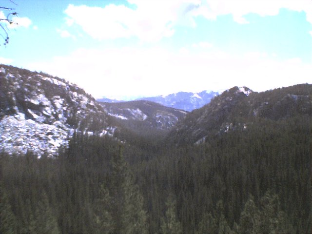
Leaving this behind, we headed north up to Yellowstone and are confounded by the fact that despite clear weather and no snow on the roads, that the route we wanted to take through the park is closed. This added about an extra two hours to our day, which will be ending in South Dakota. Yellowstone National Park is a park that needs a lot of time to explore. While a lot of sites can be seen from the road, the park is really a backcountry wonderland. There are more geysers here than any other place on the planet. The park is well protected and organized from the millions of tourist and naturalist that traverse the hundreds of miles of country to get here. One here, sites are arranged around a loop road that is in the shape of a figure 8. This provides excellent access to the back country as well as the sites close to the road. Unlike a few park, you won't have to 'hike in' to sites, most are as close as the road. This makes this park a big attraction to 'windshield tourist' who just drive around from site to site and peer out their clear silicone shields. For those who take the time, if you actually get out at some of the attractions, you'll see board walks, excellent nature trails (most under .5 miles r/t), and guides that take you beyond what you're seeing. Probably the most famous and visited attraction is Old Faithful. It has a 'Disney' like organization in its efficiency to move the thousands of tourists who just stop in for less than a half hour to see this geyser, and then leave. Outside of these, the park is a paradise for sportsmen seeking wide clear streams to fly fish in (and yes, quite a few streams here are designated fly fishing only!), large lakes to explore, and a myriad of trails for back packers.
We finally traversed the park and headed north east to go over the Bear Tooth Pass. This will lead us into Montana to our next stop and then onward to South Dakota. Getting there is another thing. This drive for me, which started out being sort of mundane, is one of the most spectular in the Rocky Mountains. The road begins rather flat, the clear fields become less numerous, and the forest becomes denser. Soon, the road begins to climb, and climb, and climb. After a while, we are confronted with snow covering the road, but the temperatures are above freezing, so there is nothing to worry about.  We stopped a few times to take some pictures at what we thought was the 'summit', but the hour was getting late and we had to press on. At one point I was looking at the road ahead of me and I saw this mountain in front of me (at this point we were above tree line) and see what looks like a road going over it. It zigged and zagged, with switch back after switchback. Reality set in when I realized that that was our road, not a side road! What an amazing sight that was! The down side was almost as good as the scene going up, but probably would have looked better if we were heading the opposite direction. As I said, this is one of the best mountain passes in the Rockies (with the one at Rocky Mountain National Park being my favorite). We stopped a few times to take some pictures at what we thought was the 'summit', but the hour was getting late and we had to press on. At one point I was looking at the road ahead of me and I saw this mountain in front of me (at this point we were above tree line) and see what looks like a road going over it. It zigged and zagged, with switch back after switchback. Reality set in when I realized that that was our road, not a side road! What an amazing sight that was! The down side was almost as good as the scene going up, but probably would have looked better if we were heading the opposite direction. As I said, this is one of the best mountain passes in the Rockies (with the one at Rocky Mountain National Park being my favorite).
We arrived a little late at our next stop, the Little Bighorn Battlefield National Monument but we still had time to explore the museum/visitor center, and then used the extra daylight to explore the monument and the National Cemetary located there. Little Bighorn Battlefield National Monument memorializes one of the last armed efforts of the Northern Plains Indians to preserve their ancestral way of life. Here in the valley of the Littel Bighorn River on two hot june days in 1876, more than 260 soldiers and attached personel of the U.S. Army met defeat and death at the hands of several thousand Lakota and Cheyenne warriors. Among the dead were Lt. Col. George Armstrong Custer and every member of his immeadiate command. Although the Indians won the battle, they subsequently lost the ware against the white man's efforts to end their independent, nomadic way of life.
Because of our delay in Yellowstone, it appears that we will not be able to see our next stop, Devils Tower National Monument, in clear daylight. Getting there was an interesting experience though. As it became darker, it was apparent that this was deer and pronghorn country. The road was very dark, and in Montana had few reflective markers by the side of the road. Wyoming did, and that helped. Every 10 miles or so (sometimes less, sometimes more) we could see the refection of our headlights in an animals eyes standing right on the side of the road. A few times the animals (either deer or pronghorn) actually did cross in front of us, require me to slam on the breaks. It really hampered our speed and forward progress, and we arrived at Devils Tower about 9pm.
Rising out of the eastern Wyoming plains lies Devils Tower National Monument. This was the first National Monument created. The tower itself was created millions of years ago when molten magma was forced into sedimentary rocks above it and cooled underground. Over the next 60 millions of years, erosion of the sedimentary rock exposed what is now Devils Tower. The tower rises 867 feet above its base, which is only 1,000 feet in diameter. The elevation at the top is 5,112 feet, which is in a tear drop shape that is 1.5 acres in size. All we can see this day is its siliuete in the dark night sky. Armed with night time photography experience, we attempted one picture, which we hoped would allow us to see this at a later time.
That was the last thing we did on this long day, which covered a lot of territory, but was just a taste of what tomorrow would be like. We stayed over night in Spearfish, SD, and prepared for the longest day of the trip.
|