Day Seven
Coronado, Chiricahua, and Fort Bowie
This is our last full day satying in Arizona. There are only three more NPS sites left in the aregion for us to visit. Today we will do all three. We got an early start because we also wanted to visit the museum at the nearby Fort Huachuca. Our guide book tells us that it open at 8, which is reasonable for a military fort, but after spending a good half hour travelling around the fort just to find it, we discover that it doesn't open until 9. That would not give us enough time to see the other 3 sites we want to today, so we moved on to the Coronado National Memorial.
The Coronado National Memorial comemorates the first European exploration of the American Southwest. It lies within sight of the San Pedro River Valley through which the Coronado Expedition first entered the present-day United States in search of the fabled Cities of Cibola. The visitor center offers a video on this expedition. From the visitor center, a road leads upward toward Montezuma Pass which offers a vista of area mountains, including some in Mexico. The monument contains a wide variety of wildlife and act to preserve them. The memorial is also known for its wide variety of birds.
Leaving Coronado, we headed northwest to the town of Bisbee. Arizona is a big producer of Copper and Bisbee is a big copper town (just like the town of Globe we visited on day 5). Here you can see a large open copper pit which is quite interesting to see. Of interest to note is that many hmes here are built into very steep hill sides. We were told that this is one of the few towns in America where the post office will not deliver right to your house. It understandable considering how some of the homes are situated. Outside of town we return the farming areas the surround this valley and head to the Chiricahua Mountains to the east.
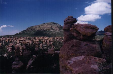
 The Chiricahua Mountains are the highest mountains located near the mexican border and capture a wide variety of birds, some normally only found in Mexico. The unique thing about the Chiricahuas is the strange and odd rock formations. The Chiricahua National Monument preserves the most bazaar of these. Exploring Chiricahua National Monument is like exploring a fantasy world of extraordinary rock structures that were created by the forces of nature over millions of years. Called the "Land of Standing-Up Rocks" by the Chiricahua Apaches and later the "Wonderland of Rocks" by pioneers, this northwest corner of the Chiricahua Mountains harbors towering rock spires, massive stone columns, and balanced rocks weighing hundreds of tons that perch delicately on small pedestals. Where hundreds of these rocks occur together, the landscape appears as a rugged badlands. The other unique characteristic is that unlike the surrounding desert valleys, the mountains are forested. The vegitation changes from cactus in the lowlands, to oaks, alligator juniper, and Arizona cypress in canyon forests, to manzanita-buckhorn-skunkbush chaparral on ridges to ponerosa pine Douglas-fir, and aspen that cover the highest slopes. The visitor center is about a mile from the entrance. Climbing gradually, Bonita Canyon Drive winds 8 miles to the mountains' crest and Massai Point. The overlook gives commanding views of thepark, desert valleys beyond and the landmark peaks of Sugarloaf Mointain and Cochise Head. The entire monument (with the exception of the road corridor) is a designated widerness area, preserving forever the state of the mountains. The Chiricahua Mountains are the highest mountains located near the mexican border and capture a wide variety of birds, some normally only found in Mexico. The unique thing about the Chiricahuas is the strange and odd rock formations. The Chiricahua National Monument preserves the most bazaar of these. Exploring Chiricahua National Monument is like exploring a fantasy world of extraordinary rock structures that were created by the forces of nature over millions of years. Called the "Land of Standing-Up Rocks" by the Chiricahua Apaches and later the "Wonderland of Rocks" by pioneers, this northwest corner of the Chiricahua Mountains harbors towering rock spires, massive stone columns, and balanced rocks weighing hundreds of tons that perch delicately on small pedestals. Where hundreds of these rocks occur together, the landscape appears as a rugged badlands. The other unique characteristic is that unlike the surrounding desert valleys, the mountains are forested. The vegitation changes from cactus in the lowlands, to oaks, alligator juniper, and Arizona cypress in canyon forests, to manzanita-buckhorn-skunkbush chaparral on ridges to ponerosa pine Douglas-fir, and aspen that cover the highest slopes. The visitor center is about a mile from the entrance. Climbing gradually, Bonita Canyon Drive winds 8 miles to the mountains' crest and Massai Point. The overlook gives commanding views of thepark, desert valleys beyond and the landmark peaks of Sugarloaf Mointain and Cochise Head. The entire monument (with the exception of the road corridor) is a designated widerness area, preserving forever the state of the mountains.
Leaving the Chiricahuas, we headed north up a few dirt roads to a trail head that would lead us to Fort Bowie National Historic Site. The fort was located in Apache Pass, an important mounatin pass separating the Chiricahua and Dos Cabezas mountians that had numerous unfailing springs. The battle of Apache Pass on July 15-16, 1862 led to the establishment of Fort Bowie to protect both the pass and the spring. Over time the fort grew and by the time of its abandonment in 1894, it was a modern post of 38 structures. This NHS comemorates the site of the fort that served as the nerve center for military campaigns against hostile Chiricahua Apaches led first by Chochise and then Geronimo. The original route into Fort Bowie was a wagon road created by the soldiers who garrisoned the post. Today, access to the fort is by way of a 1.5 mile foot trail, that generally follows the old military road. This allows you to step back from the present and into the past. The trail passes a number of historic features including the ruins of the Butterfield Stage Station, the post cemetary, Apache Spring and the site of the first Fort Bowie. A ranger station/visitor station at the fort ruins can provide water, and literature to get the most out the visit. You'll have to do some imagining while there, because there are really no structures to see, just the ruins. Sign posts along the way on the trail will let you know your progress and signs at the ruins will tell you what was once there. For those that get absorbed into historic places like this, its a must visit and the hike in makes it worth it. You really get the impression that you are in the past. As I said, this NHS just marks the site and there really is not much to see, but much to be appreciated at this site.
And so we ended another filled day of historic and scenic sites. The days are long, but the sunsets and the sites we see during the day make it worth it. We'll leave our Arizona base tomorrow and head out on the raod for real.
|