Day Twenty Three
Navajo, Wupatki, Sunset Crater Volcano, Walnut Canyon, Petrified Forest
This would not be our longest day, but it would be one of our busiest. This is our last day of sight seeing, and we there really isn't a particular thing that we want to see, but there are five NPS sites for us to see in northern Arizona. This will allow us to see them, and will know whether or not to return, and if we do, what to expect. This has been our travel philosophy for a while, and I think it has served us well.
We departed Kayenta and headed to our first stop, Navajo National Monument. The monument is located about 10 miles off of the main road in Tsegi Canyon, and offers a visitor center and representative structures of life in this region. Sheltered by overhanging cliffs, these ruins are among the best preserved in the southwest. These pueblos were built by the Puebloan people around 1250. The nearby Hopi people are descendants of the ancestral Pueblo people. These villiages are believed to have been stops along the sacred migration paths of at least eight Hopi clans. Tribal elders annually visit these villiages and other sacred shrines in the area. The have identified paintings on canyon walls as clan symbols. The NPS preserves these cultural treasures as part of this monument.
Getting from Navajo NM to our next stop was quite a task. We had to keep dealing with long construction delays, like stopping for up to half an hour while paving operations were completed. It took us an aching 3 hours to travel what should have taken us only a bit more than an hour. We reached our next site of Wupatki and Sunset Crater National Monuments. We basically just passed through and stopped at each vistor center (both parks are locally next to each other, but are separate, if you visit one, you visit both of them). In 1064 the people living just northeast of what is now Flagstaff, must have been warned by tremors before debris exploded from the ground and rained down on their pithouses. The lava flows and erupting cinders that followed forced these farmers to vacate the rocky lands they had cultivated for 400 years. A few generations later, at Wupatki and nearby Walnut Canyon, families returned to grow crops for another 100 years in the shadow of the still active Sunset Crater. Slowly, plants and animals returned too, some specially adapted to living on the lava. By the 1800's ranching and logging operations sustained the new populations settling Flagstaff, and memory of the most recent eruption on the Colorado Plateau lived only in the stories of the indigenous Southwest people. Today occasional earthquakes still remind local residents that they live in a geologically active area. Sunset Crater Volcano and Wupatki National Monuments, contemplates how the environment and people change each other. A visit to both centers needs a few hours at least, if not a half day for a complete exploration. As you drive between both areas, interpretive signs will show you how the vegetation changes with the elevation, from desert to pinyon pine forest. There are also fine views of the San Francisco Peaks, the highest in Arizona.
After visiting these two monuments, we traveled south through Flagstaff and discovered a regional National Park Service office located on U.S. 89 off I-40, exit 201. If you are doing any travel to this region and are passing through, this office, though administrative, has brochures from almost every NPS unit in the region (that includes AZ, NM, UT, and CO). The information we picked up on sites that we have not visited will prove invaluable for future trips. It could help you by having a park brochure before even going there. They also sold maps, and had other information too. Definetly worth a stop for a NPS junkie!
We then made a brief visit to Walnut Canyon National Monument. Walnut Canyon is a natural spectical as well as a historical place. 800 years ago, people took shelter in the caves and conyon walls here. Trails lead from the visitor center along the rim and into the canyon itself (185 feet down or 240 stairs). These pass the ruins of the monument that was established in 1915. From the visitor center there is a great view of the canyon, as it is located on the canyon rim.
After leaving Walnut Canyon, we made our way west on I-40 through Winslow, and paralleled the old route 66. I found it amazing that after almost 40 years that you could actually see portions of this road next to the interstate. Of course portions of the road still exist in the towns the highway travels through, but when you see a bridge just lying in the middle of no where, or a stretch of pavement that doesn't seem to connect to anything, then that is route 66. I found myself thinking of people in the past driving through this same desolate area that I was now driving through at over 75 miles an hour.
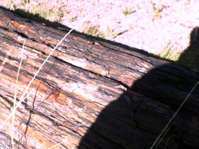
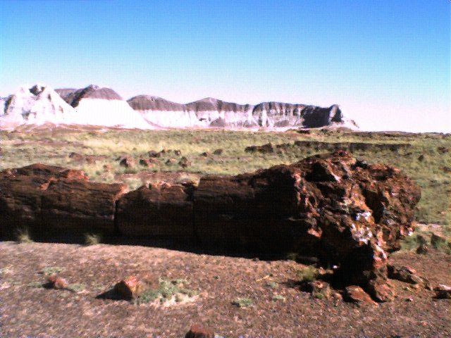
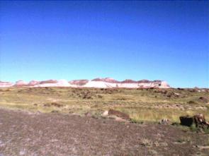 Soon enough we arrived at the final NPS area of our trip, and the last 'tourist' stop we would be making as well, Petrified Forest National Park. Despite signs telling us to exit earlier, we got off at exit 311 where the parks' visitor center is located. I think one of the best ways to visit a national park is to stop first at the visitor center, learn about it, and then explore it. Petrified Forest NP is a desert park showcasing a painted desert and preserving remnants of an ancient forest that long ago turned to stone. The painted desert area is particularly scenic. Soon enough we arrived at the final NPS area of our trip, and the last 'tourist' stop we would be making as well, Petrified Forest National Park. Despite signs telling us to exit earlier, we got off at exit 311 where the parks' visitor center is located. I think one of the best ways to visit a national park is to stop first at the visitor center, learn about it, and then explore it. Petrified Forest NP is a desert park showcasing a painted desert and preserving remnants of an ancient forest that long ago turned to stone. The painted desert area is particularly scenic. 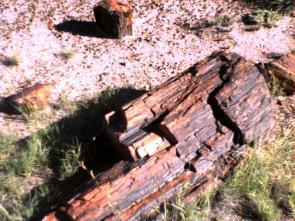 Before hitting the area of the park (southern) that contains most of the petrifeid wood, we crossed a railroad track, which shows the relative newness of this park (1906 a monument, 1962 a NP), and a most unusual sight in a national park. Here you will also find a Newspaper Rock with all kinds of Petrogliths carved into them, and the Teepees, large cone like piles of colored sand that turned to rock, and different 'forest' trails. These trails are easy .5 mile long walks that take you right beside the logs of rock that were once trees. This high, dry tableland was once a vast floodplain crossed by many streams. To the south, tall, stately pine-like trees grew along the headwaters. Before hitting the area of the park (southern) that contains most of the petrifeid wood, we crossed a railroad track, which shows the relative newness of this park (1906 a monument, 1962 a NP), and a most unusual sight in a national park. Here you will also find a Newspaper Rock with all kinds of Petrogliths carved into them, and the Teepees, large cone like piles of colored sand that turned to rock, and different 'forest' trails. These trails are easy .5 mile long walks that take you right beside the logs of rock that were once trees. This high, dry tableland was once a vast floodplain crossed by many streams. To the south, tall, stately pine-like trees grew along the headwaters.  Crocodile-like reptiles, giant fish-eating amphibians, and small dinosaurs lived among a variety of ferns, cycads, and other plants and animals that are known as fossils today. The tall trees fell and were washed by swollen streams into the floodplain. Silt, mud, and volcanic ash then covered the logs. This blanket of deposits cut off oxygen and slowed the logs decay. Gradually, silica-bearing groundwaters seeped through the logs and bit by bit, replaced the original wood tissues with silica deposits. As the process continued, the silica crystallized into quartz, and the logs were preserved as petrified wood. That was about 225 million years ago, and as the area was lifted and the sediments were washed away (a process that continues today), the logs were exposed as they are today. Upon exiting the park were were asked if we had taken any peices of the rock or 'wood'. Crocodile-like reptiles, giant fish-eating amphibians, and small dinosaurs lived among a variety of ferns, cycads, and other plants and animals that are known as fossils today. The tall trees fell and were washed by swollen streams into the floodplain. Silt, mud, and volcanic ash then covered the logs. This blanket of deposits cut off oxygen and slowed the logs decay. Gradually, silica-bearing groundwaters seeped through the logs and bit by bit, replaced the original wood tissues with silica deposits. As the process continued, the silica crystallized into quartz, and the logs were preserved as petrified wood. That was about 225 million years ago, and as the area was lifted and the sediments were washed away (a process that continues today), the logs were exposed as they are today. Upon exiting the park were were asked if we had taken any peices of the rock or 'wood'. According to estimates, millions of tons of rock have been removed from the park over the years and the NPS is taking a zero tolerance policy to theft of the material. They have even gone so far as to tell you that the same types, and grade of petrified wood are available outside of the park. Its a shame that you have to be told this in a national park. This was the fifth park we had gone into and given strict warnings (in the form of orange cards handed out) about removing , defacing, or climbing on artifacts or ruins. Its amazing because people should realize the short sightedness of such actions, destrying the very thing that they came to see. It seemed to us after visiting over 40 national park areas, that some people don't get it. According to estimates, millions of tons of rock have been removed from the park over the years and the NPS is taking a zero tolerance policy to theft of the material. They have even gone so far as to tell you that the same types, and grade of petrified wood are available outside of the park. Its a shame that you have to be told this in a national park. This was the fifth park we had gone into and given strict warnings (in the form of orange cards handed out) about removing , defacing, or climbing on artifacts or ruins. Its amazing because people should realize the short sightedness of such actions, destrying the very thing that they came to see. It seemed to us after visiting over 40 national park areas, that some people don't get it.
We drove the five hours straight back to Phoenix. We had to unload three weeks worth of material from our vehicle which took us about an hour. Trying to organize all of this into our bags was a quite a task. We worked into the night after dinner acomplishing this, and we ready to get going back home.
|