Day Eighteen
Hells Canyon
Today we are heading to the relativly remote Hells Canyon National Recreation Area. While there are more direct routes, we have decided to take a more circuitous route through eastern Oregon to visit the only point on the rim where you can actually see the Snake River below. Hells Canyon is the deepest earthen gorge in North America-some 10,000 feet deep. While not as dramatically scenic as the Grand Canyon (the walls are not colored, and its depth is not as apparent), part of the attraction is the adventure in getting there. That is why we have chosen to visit what is supposed to be the better side in which to see it, the Oregon side. To get there, we will have to travel much further west of the canyon, then back track in order to get where we want to go.
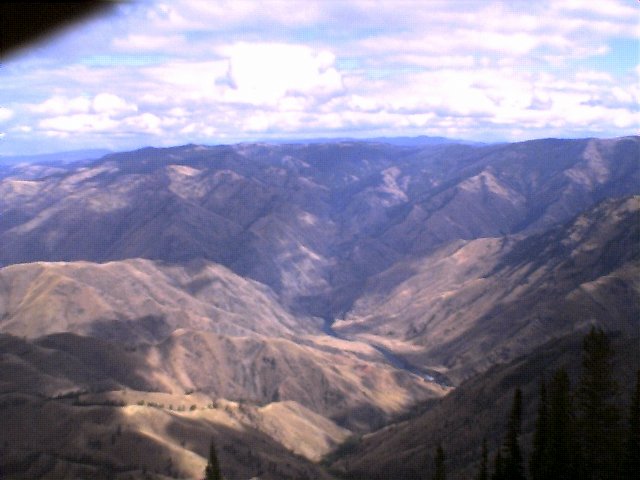
We drive west all the way back to La Grande, OR, then north and east through Enterprise and Joseph to Imnaha. This route passed just to the north of the Wallowa Mountains and the Eagle Cap Wilderness with its nearly 10,000' mountains. This area was very lush and green compared to the brown, desert we left behind us. We could even see snow up in those mountains this late September day. By the development we saw in Enterprise and Jospeh, its apparent that this beautiful valley and the mountains that surround it are slowly being discovered. From Imnaha, we took an incredible road (dirt) up several thousand feet. The first 10 miles or so have to be the most incredible. This road is definetly not for the faint of heart. After a couple of miles, it is a single lane road with pull outs and shear drop offs on one side. Its a good thing there isn't very much traffic, but when there is, you can usually find a pull out (or they do). Once on top, the road levels out and slowly climbs up to Hat Point. From Hat Point, you can climb up a fire tower and get a tremendous view which includes the only view of the Snake River and the whole canyon. The elevation here is over 10,000', and on this day we found snow flying in the air. Definetly not shorts weather, which my brother and I were wearing. You might want to consider this if you travel up here. From Hat Point, you can climb up a fire tower and get a tremendous view which includes the only view of the Snake River and the whole canyon. The elevation here is over 10,000', and on this day we found snow flying in the air. Definetly not shorts weather, which my brother and I were wearing. You might want to consider this if you travel up here.
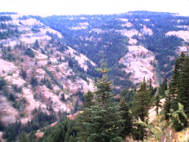
From Hat Point, we ventured all the way back to Imnaha and then south to another view point, the Hells Canyon View Point. This one was a little confusing as we had targeted the point using our gps software, and although we were following the only roads on our maps and went to the area that said it was the Hells Canyon overlook, there seem to be better roads in the area. You might want to check ahead and see if the view point has been moved. Again, a good map is helpful in navigating these back roads. From the Hells Canyon overlook, you can not see the river below, but you do get an idea of what the canyon really means. Hells Canyon consists of the Hells Canyon Wilderness, which contains thousands of acres of land for you to explore. We only did what most tourists would do if they were passing through and wanted to see Hells Canyon. From our vantage, it really needs a day to explore and more time for a hike, camp or river run. From the Hells Canyon overlook, you can not see the river below, but you do get an idea of what the canyon really means. Hells Canyon consists of the Hells Canyon Wilderness, which contains thousands of acres of land for you to explore. We only did what most tourists would do if they were passing through and wanted to see Hells Canyon. From our vantage, it really needs a day to explore and more time for a hike, camp or river run.
|